Suspension Bridges of Haute-Loire
This is a list of all 19 bridges from the suspension bridge inventory for Haute-Loire in France. Wherever you see a Bridgemeister ID number click it to isolate the bridge on its own page.
Related Lists:
1833: Coubon
Coubon and Volhac, Haute-Loire, France - Loire River
| Bridgemeister ID: | 1723 (added 2005-04-05) |
| Year Completed: | 1833 |
| Name: | Coubon |
| Location: | Coubon and Volhac, Haute-Loire, France |
| Crossing: | Loire River |
| Use: | Vehicular |
| Status: | Destroyed, 1866 |
| Main Cables: | Wire (iron) |
| Suspended Spans: | 1 |
Notes:
- Destroyed by flood, 1866.
- Replaced by 1871 Coubon - Coubon and Volhac, Haute-Loire, France.
1834: Lamothe
Lamothe and Brioude, Haute-Loire, France - Allier River
| Bridgemeister ID: | 1763 (added 2005-04-22) |
| Year Completed: | 1834 |
| Name: | Lamothe |
| Location: | Lamothe and Brioude, Haute-Loire, France |
| Crossing: | Allier River |
| Coordinates: | 45.302910 N 3.403816 E |
| Maps: | Acme, GeoHack, Google, OpenStreetMap |
| References: | AAJ |
| Use: | Vehicular |
| Status: | Only towers remain (last checked: 2011) |
| Main Cables: | Wire (iron) |
| Suspended Spans: | 2 |
| Main Spans: | 2 |
Notes:
- 1866: A flood causes a major change in the course of the Allier River such that the main channel no longer flows under the bridge. The bridge, however, is not destroyed. A new suspension bridge is built in the 1880s over the main channel of the Allier just slightly east of the older bridge.
- All three pairs of pylons were still standing in the 2010s.
- Similar to 1833 Cosne-sur-Loire - Cosne-sur-Loire, Nièvre and Boulleret, Cher, France in appearance of towers.
- Similar to 1834 Jargeau (Saint-Denis-de-l'Hôtel) - Jargeau and Saint-Denis-de-l'Hôtel, Loiret, France in appearance of towers.
- Near 1884 Lamothe - Lamothe and Brioude, Haute-Loire, France.
External Links:
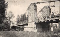
1835: Langeac
Langeac, Haute-Loire, France - Allier River
| Bridgemeister ID: | 1701 (added 2005-03-29) |
| Year Completed: | 1835 |
| Name: | Langeac |
| Location: | Langeac, Haute-Loire, France |
| Crossing: | Allier River |
| Coordinates: | 45.100706 N 3.498480 E |
| Maps: | Acme, GeoHack, Google, OpenStreetMap |
| References: | AAJ |
| Use: | Vehicular |
| Status: | Replaced, 1929 |
| Main Cables: | Wire (iron) |
| Suspended Spans: | 2 |
| Main Spans: | 2 |
Notes:
- AAJ guesses this bridge was completed in 1835 based on contract let in 1833 specifying a two-year construction period.
External Links:
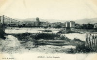
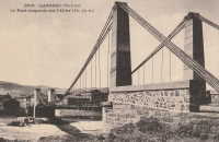
- Art-et-Histoire - Troisième pont suspendu de Langeac - 1868. Indicates the bridge depicted here was competed 1868 after the first (1835) and second (1860) Langeac suspension bridges were destroyed by flood.
1845: Auzon
Auzon, Haute-Loire, France - Allier River
| Bridgemeister ID: | 6934 (added 2022-01-22) |
| Year Completed: | 1845 |
| Name: | Auzon |
| Location: | Auzon, Haute-Loire, France |
| Crossing: | Allier River |
| Coordinates: | 45.385847 N 3.356905 E |
| Maps: | Acme, GeoHack, Google, OpenStreetMap |
| Status: | Destroyed, October 18, 1846 |
Notes:
- Replaced by 1847 Auzon - Auzon, Haute-Loire, France.
External Links:
- Art-et-Histoire - Premier pont suspendu d'Auzon - 1845. Bridge is destroyed by flood, October 18, 1846.
1847: Auzon
Auzon, Haute-Loire, France - Allier River
| Bridgemeister ID: | 6935 (added 2022-01-22) |
| Year Completed: | 1847 |
| Name: | Auzon |
| Location: | Auzon, Haute-Loire, France |
| Crossing: | Allier River |
| Coordinates: | 45.385816 N 3.356742 E |
| Maps: | Acme, GeoHack, Google, OpenStreetMap |
| Status: | Destroyed, September 26, 1866 |
Notes:
- Replaced 1845 Auzon - Auzon, Haute-Loire, France.
- Replaced by 1870 Auzon - Auzon, Haute-Loire, France.
External Links:
- Art-et-Histoire - Premier pont suspendu d'Auzon - 1845. Deck is destroyed by windstorm, January 20, 1854. Weakened by flood, in 1856. Bridge is repaired, but is eventually destroyed by flood in 1866.
1850: Retournac
Retournac, Haute-Loire, France - Loire River
| Bridgemeister ID: | 4066 (added 2020-03-31) |
| Year Completed: | 1850 |
| Name: | Retournac |
| Location: | Retournac, Haute-Loire, France |
| Crossing: | Loire River |
| Use: | Vehicular |
| Status: | Destroyed, 1866 |
Notes:
- Destroyed by flood, 1866
- Replaced Retournac - Retournac, Haute-Loire, France.
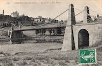
1851: Chadrac
Chadrac, Haute-Loire, France - Loire River
| Bridgemeister ID: | 7864 (added 2023-09-15) |
| Year Completed: | 1851 |
| Name: | Chadrac |
| Location: | Chadrac, Haute-Loire, France |
| Crossing: | Loire River |
| Use: | Vehicular |
| Status: | Removed |
| Main Cables: | Wire (iron) |
| Suspended Spans: | 1 |
External Links:
1863: Confolent
Confolent, Beauzac vicinity and Saint-Marice-de-Lignon, Haute-Loire, France - Loire River
| Bridgemeister ID: | 412 (added before 2003) |
| Year Completed: | 1863 |
| Name: | Confolent |
| Also Known As: | Lignon |
| Location: | Confolent, Beauzac vicinity and Saint-Marice-de-Lignon, Haute-Loire, France |
| Crossing: | Loire River |
| Coordinates: | 45.258031 N 4.144228 E |
| Maps: | Acme, GeoHack, Google, OpenStreetMap |
| Principals: | Adolphe Boulland |
| References: | BPF |
| Use: | Vehicular (one-lane), with walkway |
| Status: | In use (last checked: 2019) |
| Main Cables: | Wire (iron) |
| Suspended Spans: | 1 |
Notes:
- Cables damaged 1913, 1921. Refurbished 1922.
External Links:

1870: Auzon
Auzon, Haute-Loire, France - Allier River
| Bridgemeister ID: | 6936 (added 2022-01-22) |
| Year Completed: | 1870 |
| Name: | Auzon |
| Location: | Auzon, Haute-Loire, France |
| Crossing: | Allier River |
| Coordinates: | 45.385908 N 3.357088 E |
| Maps: | Acme, GeoHack, Google, OpenStreetMap |
| Use: | Vehicular (one-lane) |
| Status: | Removed, c. 1934 |
| Main Cables: | Wire |
| Main Span: | 1 |
Notes:
- Replaced by an arch bridge in 1934.
- Replaced 1847 Auzon - Auzon, Haute-Loire, France.
External Links:

1871: Coubon
Coubon and Volhac, Haute-Loire, France - Loire River
| Bridgemeister ID: | 1724 (added 2005-04-05) |
| Year Completed: | 1871 |
| Name: | Coubon |
| Location: | Coubon and Volhac, Haute-Loire, France |
| Crossing: | Loire River |
| Use: | Vehicular |
| Status: | Destroyed, 1930 |
| Main Cables: | Wire |
| Suspended Spans: | 1 |
Notes:
External Links:

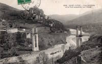
1879: Saint-Ilpize
Saint-Ilpize, Haute-Loire, France - Allier River
| Bridgemeister ID: | 1097 (added 2004-01-02) |
| Year Completed: | 1879 |
| Name: | Saint-Ilpize |
| Location: | Saint-Ilpize, Haute-Loire, France |
| Crossing: | Allier River |
| Coordinates: | 45.198556 N 3.386866 E |
| Maps: | Acme, GeoHack, Google, OpenStreetMap |
| Principals: | Ferdinand Arnodin |
| References: | AAJ, BPF, HBE, PTS2 |
| Use: | Vehicular (one-lane) |
| Status: | In use (last checked: 2020) |
| Main Cables: | Wire |
| Suspended Spans: | 3 |
| Main Span: | 1 x 70.35 meters (230.8 feet) |
| Side Spans: | 2 |
| Deck width: | 18 feet |
Notes:
- The side spans are supported solely by inclined stays, not suspenders from the main cables.
- Closed to all traffic on July 15, 2004 due to damage to the deck, possibly caused by an overloaded truck. Repaired and reopened.
External Links:
1883: Chilhac
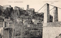
Chilhac, Haute-Loire, France - Allier River
| Bridgemeister ID: | 1131 (added 2004-01-15) |
| Year Completed: | 1883 |
| Name: | Chilhac |
| Location: | Chilhac, Haute-Loire, France |
| Crossing: | Allier River |
| Coordinates: | 45.154731 N 3.437122 E |
| Maps: | Acme, GeoHack, Google, OpenStreetMap |
| Use: | Vehicular (one-lane) |
| Status: | In use (last checked: 2019) |
| Main Cables: | Wire |
| Suspended Spans: | 1 |
External Links:
1884: Lamothe
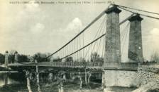
Lamothe and Brioude, Haute-Loire, France - Allier River
| Bridgemeister ID: | 1764 (added 2005-04-22) |
| Year Completed: | 1884 |
| Name: | Lamothe |
| Location: | Lamothe and Brioude, Haute-Loire, France |
| Crossing: | Allier River |
| Coordinates: | 45.302968 N 3.406201 E |
| Maps: | Acme, GeoHack, Google, OpenStreetMap |
| References: | PTS2 |
| Use: | Vehicular |
| Status: | Only towers remain, since 1977 (last checked: 2019) |
| Main Cables: | Wire |
| Suspended Spans: | 1 |
| Main Span: | 1 |
Notes:
- Next to 1834 Lamothe - Lamothe and Brioude, Haute-Loire, France. In 1866, a flood caused a major change in the course of the Allier River such that the main channel no longer flowed under the older bridge. The newer bridge crossed the main channel of the Allier just slightly east of the older bridge.
External Links:

1892: Aurec-sur-Loire
Aurec-sur-Loire, Haute-Loire, France - Loire River
| Bridgemeister ID: | 1607 (added 2005-02-06) |
| Year Completed: | 1892 |
| Name: | Aurec-sur-Loire |
| Location: | Aurec-sur-Loire, Haute-Loire, France |
| Crossing: | Loire River |
| Coordinates: | 45.369475 N 4.196837 E |
| Maps: | Acme, GeoHack, Google, OpenStreetMap |
| Use: | Vehicular (one-lane) |
| Status: | Only towers remain (last checked: 2021) |
| Main Cables: | Wire |
| Suspended Spans: | 3 |
| Main Span: | 1 |
| Side Spans: | 2 |
Notes:
- Approaches, abutments, piers, and pylons still in existence, 2018, but the original deck and cables are completely gone. A newer pedestrian suspension bridge is effectively sitting on the original bridge's piers between the original pylons.
- Later at same location (footbridge) - Aurec-sur-Loire, Haute-Loire, France.

1898: Margeaix
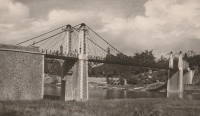
Beaulieu and Saint-Vincent, Haute-Loire, France - Loire River
| Bridgemeister ID: | 1539 (added 2004-10-31) |
| Year Completed: | 1898 |
| Name: | Margeaix |
| Also Known As: | Marjeaix, Margeix |
| Location: | Beaulieu and Saint-Vincent, Haute-Loire, France |
| Crossing: | Loire River |
| Coordinates: | 45.15324 N 3.924896 E |
| Maps: | Acme, GeoHack, Google, OpenStreetMap |
| References: | BPF |
| Use: | Vehicular (one-lane) |
| Status: | In use (last checked: 2019) |
| Main Cables: | Wire |
| Suspended Spans: | 1 |
| Main Span: | 1 x 66 meters (216.5 feet) |
Notes:
- Repaired, 1935 and 1975.
External Links:

(footbridge)
Aurec-sur-Loire, Haute-Loire, France - Loire River
| Bridgemeister ID: | 6806 (added 2021-11-21) |
| Name: | (footbridge) |
| Location: | Aurec-sur-Loire, Haute-Loire, France |
| Crossing: | Loire River |
| Coordinates: | 45.369532 N 4.197222 E |
| Maps: | Acme, GeoHack, Google, OpenStreetMap |
| Use: | Footbridge |
| Status: | In use (last checked: 2021) |
| Main Cables: | Wire (steel) |
| Suspended Spans: | 3 |
| Main Span: | 1 |
| Side Spans: | 2 |
Notes:
- 2010s: This suspension footbridge is installed on the piers of the old vehicular suspension bridge at this location.
- At former location of 1892 Aurec-sur-Loire - Aurec-sur-Loire, Haute-Loire, France.
Bas-Monistrol
Bas-en-Basset and Monistrol-sur-Loire, Haute-Loire, France - Loire River
| Bridgemeister ID: | 3334 (added 2019-12-08) |
| Name: | Bas-Monistrol |
| Location: | Bas-en-Basset and Monistrol-sur-Loire, Haute-Loire, France |
| Crossing: | Loire River |
| Coordinates: | 45.294889 N 4.118132 E |
| Maps: | Acme, GeoHack, Google, OpenStreetMap |
| References: | AAJ |
| Use: | Vehicular |
| Status: | Only towers remain (last checked: 2018) |

Retournac
Retournac, Haute-Loire, France - Loire River
| Bridgemeister ID: | 4065 (added 2020-03-31) |
| Name: | Retournac |
| Location: | Retournac, Haute-Loire, France |
| Crossing: | Loire River |
| References: | AAJ |
| Use: | Vehicular |
| Status: | Destroyed, 1846 |
Notes:
- AAJ supposes this bridge was completed in 1841 based a contract let in early 1839 for a two-year construction duration. Other sources suggest 1838 or 1839, but appear to be based on the contract date and not the completion of construction.
- Destroyed by flood, 1846.
- Replaced by 1850 Retournac - Retournac, Haute-Loire, France.
Vaure
Vaures and Bransac, Haute-Loire, France - Loire River
| Bridgemeister ID: | 7555 (added 2023-03-19) |
| Name: | Vaure |
| Location: | Vaures and Bransac, Haute-Loire, France |
| Crossing: | Loire River |
| Coordinates: | 45.234554 N 4.094460 E |
| Maps: | Acme, GeoHack, Google, OpenStreetMap |
| Use: | Vehicular |
| Status: | Removed |
| Suspended Spans: | 1 |
Do you have any information or photos for these bridges that you would like to share? Please email david.denenberg@bridgemeister.com.