Undated Suspension Bridges (1-100 of 6,195)
This is a list of bridges 1 through 100 (of 6,195 total) having no year of completion in the suspension bridge inventory. Wherever you see a Bridgemeister ID number click it to isolate the bridge on its own page.
Related Lists:
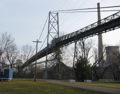
Bridgemeister ID: 2572 (added 2012-11-17)Name: (conveyor bridge) Location: Beverly vicinity, Ohio , USA Crossing: Muskingum River At or Near Feature: Muskingum River Power Plant Coordinates: 39.59230 N 81.68519 W Maps: Acme , GeoHack , Google , OpenStreetMap Use: Conveyor Status: Removed, c. 2015-2021 Main Cables: Wire (steel) Suspended Spans: 1
Approaches were dismantled by 2015. Another portion of the beltway collapsed during preparations for demolition in December 2015 killing the CEO of the demolition company. Unclear if the suspension span was completely demolished at this time. By 2021, the bridge appears to have been completely demolished. Bridgemeister ID: 7391 (added 2022-11-25)Name: (conveyor bridge) Location: Gary, West Virginia , USA Coordinates: 37.373762 N 81.558262 W Maps: Acme , GeoHack , Google , OpenStreetMap Use: Conveyor Status: Extant (last checked: 2020) Main Cables: Wire (steel) Main Span: 1 x 179 meters (587.3 feet) estimated
Bridgemeister ID: 2574 (added 2012-11-18)Name: (conveyor bridge) Location: Joliet, Illinois , USA Crossing: Des Plaines River At or Near Feature: Joliet 29 Generating Station Coordinates: 41.494281 N 88.119729 W Maps: Acme , GeoHack , Google , OpenStreetMap Use: Conveyor Status: Extant (last checked: 2012) Main Cables: Wire (steel)
Bridgemeister ID: 2034 (added 2006-05-01)Name: (conveyor bridge) Location: Pasco vicinity, Washington , USA Crossing: Snake River At or Near Feature: Ice Harbor Lock and Dam Principals: John A. Roebling's Sons Use: Conveyor Status: Removed Main Cables: Wire (steel) Suspended Spans: 1 Main Span: 1 x 304.8 meters (1,000 feet)
Built late 1950s or 1960. Pictured and described in Roebling ad in July 1960 issue of Civil Engineering. Built to transport concrete aggregate during construction of the dam. Likely removed. Bridgemeister ID: 1951 (added 2005-11-04)Name: (conveyor bridge) Location: Starbrick, Pennsylvania , USA Crossing: Allegheny River Coordinates: 41.837083 N 79.20475 W Maps: Acme , GeoHack , Google , OpenStreetMap Use: Conveyor Status: Removed (last checked: 2008) Main Cables: Wire (steel) Suspended Spans: 1 Main Span: 1 x 115.8 meters (380 feet) estimated
Crossed a portion of the Allegheny River to Mead Island. Appears to have been removed 2006-2008. Jason Oliphant writes in early 2009: "The north shore suspension supports still exist but the bridge doesn't. I have no idea when it was taken down but I can say that it wasn't there in summer 2008." Bridgemeister ID: 6062 (added 2021-07-03)Name: (conveyor bridge) Location: Takahashi, Okayama , Japan Crossing: Nariwa River Coordinates: 34.786127 N 133.479621 E Maps: Acme , GeoHack , Google , OpenStreetMap Use: Conveyor Status: Extant (last checked: 2014) Main Cables: Wire (steel) Main Span: 1 x 122 meters (400.3 feet) estimated
Bridgemeister ID: 1615 (added 2005-02-22)Name: (conveyor bridge) Location: Thornton, Colorado , USA Crossing: South Platte River Coordinates: 39.86809 N 104.92068 W Maps: Acme , GeoHack , Google , OpenStreetMap Use: Pipeline and Footbridge Status: Derelict (last checked: 2007) Main Cables: Wire (steel) Suspended Spans: 1 Main Span: 1 x 121.9 meters (400 feet) estimated
Bridgemeister ID: 1630 (added 2005-03-11)Name: (conveyor bridge) Location: Thornton, Colorado , USA Crossing: South Platte River Coordinates: 39.87968 N 104.90335 W Maps: Acme , GeoHack , Google , OpenStreetMap Use: Conveyor and Footbridge Status: In use (last checked: 2007) Main Cables: Wire (steel) Suspended Spans: 1 Main Span: 1 x 106.7 meters (350 feet)
Bridgemeister ID: 2971 (added 2019-10-12)Name: (flume bridge) Location: Grovane vicinity, Vennesla, Agder, Norway Coordinates: 58.309513 N 7.966079 E Maps: Acme , GeoHack , Google , kart.1881.no , OpenStreetMap Use: Flume Status: Extant (last checked: 2019) Main Cables: Wire (steel) Suspended Spans: 1
Bridgemeister ID: 2977 (added 2019-10-12)Name: (flume bridge) Location: Grovane vicinity, Vennesla, Agder, Norway Coordinates: 58.317199 N 7.953377 E Maps: Acme , GeoHack , Google , kart.1881.no , OpenStreetMap Use: Flume Status: Extant (last checked: 2016) Main Cables: Wire (steel) Suspended Spans: 1
Based on historic aerial images built prior to 1972 and removed between 1980 and 2004. Bridgemeister ID: 4200 (added 2020-04-08)Name: (flume bridge) Location: Notodden, Vestfold Og Telemark, Norway Crossing: Tinnåa At or Near Feature: Svelgfoss Gorge Coordinates: 59.583446 N 9.267132 E Maps: Acme , GeoHack , Google , kart.1881.no , OpenStreetMap Use: Flume Status: Extant (last checked: 2019) Main Span: 1 x 45 meters (147.6 feet) estimated
Bridgemeister ID: 4201 (added 2020-04-08)Name: (flume bridge) Location: Notodden, Vestfold Og Telemark, Norway Crossing: Tinnåa At or Near Feature: Svelgfossjuvet Coordinates: 59.589983 N 9.271374 E Maps: Acme , GeoHack , Google , kart.1881.no , OpenStreetMap Use: Flume Status: Extant (last checked: 2019) Main Span: 1 x 70 meters (229.7 feet) estimated
Bridgemeister ID: 1692 (added 2005-03-27)Name: (flume bridge) Location: Proctor, Vermont , USA Crossing: Otter Creek At or Near Feature: Sutherland Falls Use: Flume Status: Removed Main Cables: Wire
The postcard presented here doesn't show much, but other photos show a large wood-shingled tower at one end of the bridge. The bridge was likely completed in the late 1800s. Robert Ratti provided the following information: "it was a carrier of marble slurry from the Vermont Marble Co. and ended in the swamp nearby... In 1936, I lived right at the end of the swamp and climbed on that waste carrier many times." Bridgemeister ID: 4469 (added 2020-04-26)Name: (flume bridge) Location: Skotfoss, Skien, Vestfold og Telemark, Norway Crossing: Meierelva Coordinates: 59.207638 N 9.527812 E Maps: Acme , GeoHack , Google , kart.1881.no , OpenStreetMap Use: Flume Status: Removed Main Cables: Wire (steel) Main Spans: 1 x 100 meters (328.1 feet) estimated,
Bridgemeister ID: 4860 (added 2020-07-12)Name: (footbridge) Also Known As: きしべはし Location: Kinokawa, Wakayama , Japan Crossing: Kishi River Coordinates: 34.203697 N 135.311855 E Maps: Acme , GeoHack , Google , OpenStreetMap Use: Footbridge Status: In use (last checked: 2019) Main Cables: Wire (steel) Suspended Spans: 1
Bridgemeister ID: 6267 (added 2021-07-18)Name: (footbridge) Location: Abadzekhskaya (Абадзехская), Adygea Republic, Russia Crossing: Reka Belaya Coordinates: 44.389362 N 40.212834 E Maps: Acme , GeoHack , Google , OpenStreetMap Use: Footbridge Status: In use (last checked: 2018) Main Cables: Wire (steel) Main Span: 1 x 105.2 meters (345 feet) estimated Side Span: 1 x 44.2 meters (145 feet) estimated
Bridgemeister ID: 1246 (added 2004-02-16)Name: (footbridge) Location: Abisko vicinity, Abisko National Park, Sweden Coordinates: 68.28423 N 18.59086 E Maps: Acme , GeoHack , Google , OpenStreetMap Use: Footbridge Status: In use Main Cables: Wire (steel)
Narrow metal footbridge. Has link chains for suspenders. Bridgemeister ID: 6172 (added 2021-07-08)Name: (footbridge) Location: Acharisaghmarti, Georgia Coordinates: 41.519608 N 41.792892 E Maps: Acme , GeoHack , Google , OpenStreetMap Use: Footbridge Status: In use (last checked: 2021) Main Cables: Wire (steel) Suspended Spans: 1
Bridgemeister ID: 7885 (added 2023-10-07)Name: (footbridge) Location: Aco, Peru Crossing: Rio Santa Coordinates: 9.644386 S 77.488165 W Maps: Acme , GeoHack , Google , OpenStreetMap Use: Footbridge Status: In use (last checked: 2022) Main Cables: Wire (iron) Suspended Spans: 1 Main Span: 1 x 57 meters (187 feet) estimated
Completed at some point in the 2014-2016 time frame. Bridgemeister ID: 2558 (added 2012-01-15)Name: (footbridge) Location: Adana, Türkiye Crossing: Seyhan River Coordinates: 37.00017 N 35.33750 E Maps: Acme , GeoHack , Google , OpenStreetMap Use: Footbridge Status: In use (last checked: 2011) Main Cables: Wire (steel) Suspended Spans: 3 Main Span: 1 Side Spans: 2
Bridgemeister ID: 2559 (added 2012-01-15)Name: (footbridge) Location: Adana, Türkiye Crossing: Seyhan River Coordinates: 36.99724 N 35.33793 E Maps: Acme , GeoHack , Google , OpenStreetMap Use: Footbridge Status: In use (last checked: 2011) Main Cables: Wire (steel) Suspended Spans: 3 Main Span: 1 Side Spans: 2
Bridgemeister ID: 6909 (added 2022-01-21)Name: (footbridge) Location: Agoyán, Ecuador Crossing: Rio Pastaza At or Near Feature: Cascada Manto de la Novia Coordinates: 1.403847 S 78.334456 W Maps: Acme , GeoHack , Google , OpenStreetMap Use: Footbridge Status: In use (last checked: 2018) Main Cables: Wire (steel) Main Span: 1
Bridgemeister ID: 8282 (added 2024-02-08)Name: (footbridge) Location: Agua Caliente, Padilla, Bolivia Coordinates: 19.563972 S 64.104250 W Maps: Acme , GeoHack , Google , OpenStreetMap Use: Footbridge Status: Extant (last checked: 2024) Main Span: 1
Bridgemeister ID: 3438 (added 2019-12-22)Name: (footbridge) Location: Aguas Calientes, Machu Picchu, Peru Crossing: Urubamba River Coordinates: 13.187022 S 72.529714 W Maps: Acme , GeoHack , Google , OpenStreetMap Use: Footbridge Status: Extant (last checked: 2015) Main Cables: Wire (steel)
Bridgemeister ID: 3439 (added 2019-12-22)Name: (footbridge) Location: Aguas Calientes, Machu Picchu, Peru Crossing: Urubamba River At or Near Feature: Inca Trail 104 Km Checkpoint Coordinates: 13.186273 S 72.508611 W Maps: Acme , GeoHack , Google , OpenStreetMap Use: Footbridge Status: In use (last checked: 2019) Main Cables: Wire (steel) Suspended Spans: 1
Bridgemeister ID: 6500 (added 2021-08-22)Name: (footbridge) Location: Ajmeer, Khyber Pakhtunkhwa, Pakistan Coordinates: 35.078937 N 72.757762 E Maps: Acme , GeoHack , Google , OpenStreetMap Use: Footbridge Status: In use (last checked: 2021) Main Cables: Wire (steel) Suspended Spans: 1 Main Span: 1 x 22.9 meters (75 feet) estimated
Built at some point in 2011-2013 time frame. Appears to have been damaged by flood in the 2018-2019 time frame. Bridgemeister ID: 1151 (added 2004-01-18)Name: (footbridge) Location: Akron, Ohio , USA Crossing: Cuyahoga River At or Near Feature: High Bridge Glens Park, now Gorge Metro Park Use: Footbridge Status: Removed Main Cables: Wire
This bridge is visible in the foreground of a popular late 19th century stereoview showing the "high bridge" and falls. No longer in existence. Bridgemeister ID: 1784 (added 2005-05-16)Name: (footbridge) Location: Akron, Ohio , USA At or Near Feature: F.A. Seiberling Nature Realm, Sand Run Metro Park Coordinates: 41.135883 N 81.5735 W Maps: Acme , GeoHack , Google , OpenStreetMap Use: Footbridge Status: In use (last checked: 2012) Main Cables: Wire Suspended Spans: 1
Adjacent to Ranighat Palace (Rani Mahal). Bridgemeister ID: 6758 (added 2021-10-24)Name: (footbridge) Location: Alatyr (Алатырь), Chuvashia Republic, Russia Crossing: Reka Alatyr Coordinates: 54.870633 N 46.584543 E Maps: Acme , GeoHack , Google , OpenStreetMap Use: Footbridge Status: In use (last checked: 2021) Main Cables: Wire (steel) Suspended Spans: 1 Main Span: 1
Bridgemeister ID: 9002 (added 2024-12-25)Name: (footbridge) Location: Albarracín, Teruel, Spain Crossing: Rio Guadalaviar Coordinates: 40.404778 N 1.442500 W Maps: Acme , GeoHack , Google , OpenStreetMap Use: Footbridge Status: In use (last checked: 2024) Main Cables: Chain Suspended Spans: 1 Main Span: 1 x 14 meters (45.9 feet) estimated
Bridgemeister ID: 9003 (added 2024-12-25)Name: (footbridge) Location: Aldeire, Granada, Spain Crossing: Rio Benéjar Coordinates: 37.145306 N 3.074278 W Maps: Acme , GeoHack , Google , OpenStreetMap Use: Footbridge Status: In use (last checked: 2019) Main Cables: Wire (steel) Suspended Spans: 1 Main Span: 1
Bridgemeister ID: 3223 (added 2019-11-11)Name: (footbridge) Location: Alijosiskes, Lithuania Coordinates: 55.390022 N 22.233411 E Maps: Acme , GeoHack , Google , OpenStreetMap Use: Footbridge Status: In use (last checked: 2019) Main Cables: Wire (steel) Main Span: 1
There are several small bridges in the park at this location. A small level deck suspension bridge was observed at the coordinates indicated in the late 2010s. There is at least one other droopy suspension bridge in the park. Bridgemeister ID: 5810 (added 2021-04-10)Name: (footbridge) Location: Alishan Township, Chiayi County, Taiwan At or Near Feature: Shipangu Falls - 石盤谷瀑布 Coordinates: 23.599119 N 120.745541 E Maps: Acme , GeoHack , Google , OpenStreetMap Use: Footbridge Status: In use (last checked: 2020) Main Cables: Wire (steel) Main Span: 1
Bridgemeister ID: 5811 (added 2021-04-11)Name: (footbridge) Location: Alishan Township, Chiayi County, Taiwan Coordinates: 23.592602 N 120.746110 E Maps: Acme , GeoHack , Google , OpenStreetMap Use: Footbridge Status: In use (last checked: 2017) Main Cables: Wire (steel) Main Span: 1
Bridgemeister ID: 2744 (added 2019-06-23)Name: (footbridge) Location: Alishan Township, Taiwan At or Near Feature: Danaiku Nature Ecological Park Coordinates: 23.381680 N 120.682677 E Maps: Acme , GeoHack , Google , OpenStreetMap Use: Footbridge Status: In use (last checked: 2019) Main Cables: Wire (steel)
Bridgemeister ID: 1792 (added 2005-05-17)Name: (footbridge) Location: Alnasca, Brione, Ticino, Switzerland Crossing: Verzasca River At or Near Feature: Val Verzasca Coordinates: 46.304296 N 8.795310 E Maps: Acme , GeoHack , Google , OpenStreetMap Use: Footbridge Status: In use (last checked: 2014) Main Cables: Wire (steel) Suspended Spans: 1 Main Span: 1 x 79 meters (259.2 feet) Deck width: 1.1 meters
Only one tower. On one side the cables are anchored directly into rock. Bridgemeister ID: 3027 (added 2019-10-13)Name: (footbridge) Location: Altja, Lääne-Viru County, Estonia At or Near Feature: Lahemaa National Park Coordinates: 59.585815 N 26.117792 E Maps: Acme , GeoHack , Google , OpenStreetMap Use: Footbridge Status: In use (last checked: 2020) Main Cables: Wire (steel) Suspended Spans: 1
Bridgemeister ID: 1342 (added 2004-05-08)Name: (footbridge) Location: Alum Wells vicinity and Craigs Mill vicinity, Virginia , USA Crossing: North Fork Holston River At or Near Feature: Buffalo Ford Coordinates: 36.74740 N 82.18636 W Maps: Acme , GeoHack , Google , OpenStreetMap Principals: VDOT Use: Footbridge Status: In use (last checked: 2004) Main Cables: Wire (steel) Suspended Spans: 2 Main Span: 1 x 58.2 meters (191 feet) estimated Side Span: 1 x 18.3 meters (60 feet) estimated
Bridgemeister ID: 1926 (added 2005-10-23)Name: (footbridge) Location: Amden vicinity, Switzerland Coordinates: 47.141933 N 9.14025 E Maps: Acme , GeoHack , Google , OpenStreetMap Use: Footbridge Status: In use (last checked: 2005) Main Cables: Wire Suspended Spans: 1
Narrow footbridge with A-shaped towers. Bridgemeister ID: 3885 (added 2020-03-13)Name: (footbridge) Location: Anikovo (Аниково) and Karinskoye (Каринское), Moscow Oblast, Russia Crossing: Moskva River Coordinates: 55.705680 N 36.688922 E Maps: Acme , GeoHack , Google , OpenStreetMap Use: Footbridge Status: In use (last checked: 2022) Main Cables: Wire (steel)
Bridgemeister ID: 1689 (added 2005-03-27)Name: (footbridge) Location: Antes Fort vicinity, Pennsylvania , USA Crossing: Antes Creek Coordinates: 41.179603 N 77.226050 W Maps: Acme , GeoHack , Google , OpenStreetMap Use: Footbridge Status: In use (last checked: 2020) Main Cables: Wire (steel) Suspended Spans: 1 Main Span: 1 x 30.8 meters (101 feet) estimated
Bridgemeister ID: 7248 (added 2022-07-16)Name: (footbridge) Location: Antonio Stomayor, Los Rios, Ecuador Crossing: Rio Vinces Coordinates: 1.639569 S 79.802726 W Maps: Acme , GeoHack , Google , OpenStreetMap Use: Footbridge Status: In use (last checked: 2017) Main Cables: Wire (steel) Main Span: 1 x 159 meters (521.7 feet) estimated
Bridgemeister ID: 5839 (added 2021-05-09)Name: (footbridge) Location: Aoba Ward, Yokohama, Kanagawa , Japan At or Near Feature: Kodomo no Kuni Coordinates: 35.562558 N 139.490068 E Maps: Acme , GeoHack , Google , OpenStreetMap Use: Footbridge Status: In use (last checked: 2021) Main Cables: Wire (steel) Suspended Spans: 1
Bridgemeister ID: 7404 (added 2022-12-04)Name: (footbridge) Location: Apartadó, Antioquia, Colombia Crossing: Rio Apartadó Coordinates: 7.881961 N 76.627881 W Maps: Acme , GeoHack , Google , OpenStreetMap Use: Footbridge Status: Removed, c. 2017-2018 Main Cables: Wire (steel) Suspended Spans: 1 Main Span: 1 x 56.4 meters (185 feet) estimated
Twitter . March 19, 2015: Photos of the inauguration of a nearby replacement bridge and one image of the suspension bridge.Bridgemeister ID: 1629 (added 2005-03-11)Name: (footbridge) Location: Apertin, Sweden Coordinates: 59.51675 N 13.36985 E Maps: Acme , GeoHack , Google , OpenStreetMap Use: Footbridge Status: In use (last checked: 2021)
apopaonline.com - Video: Apopa El Puente Se Esta Cayendo, Esta Tarde Se Cayo Una Señora Y La Alcaldia No Hace Nada . Images and video of the poor condition of the bridge.Facebook . Image of repairs being made to the bridge's suspenders, posted April 23, 2013.Facebook . Image of repairs being made to the bridge's suspenders, posted April 23, 2013.Facebook - Los angeles apopa puente de amaca . Video of a flood at the bridge, posted May 31, 2020.Facebook - Puente en colonia Los Angeles Apopa . Image of the bridge, posted February 19, 2012.Twitter - Apopa, Puente De Colonia Los Angeles Se Esta Cayendo, Pasan Niños, Ancianos Y Se Pueden Caer . Video of the poor condition of the bridge, posted January 7, 2022.Facebook . Image of the bridge posted in 2019.Facebook . Image of the bridge posted in 2017.Bridgemeister ID: 7335 (added 2022-09-03)Name: (footbridge) Location: Arando, Gilgit-Baltistan, Pakistan Crossing: Shigar River Coordinates: 35.868625 N 75.334283 E Maps: Acme , GeoHack , Google , OpenStreetMap Use: Footbridge Status: In use (last checked: 2021) Main Cables: Wire (steel) Suspended Spans: 1 Main Span: 1 x 49.4 meters (162 feet) estimated
Bridgemeister ID: 7475 (added 2022-12-25)Name: (footbridge) Location: Arashiyama Kitamatsuoyama, Nishikyo Ward, Kyoto , Japan Crossing: Katsura River At or Near Feature: Hozukyō Gorge - 保津峡 Coordinates: 35.026157 N 135.645702 E Maps: Acme , GeoHack , Google , OpenStreetMap Use: Footbridge Status: In use Main Cables: Wire (steel) Suspended Spans: 1 Main Span: 1 x 50 meters (164 feet) estimated
Bridgemeister ID: 3339 (added 2019-12-14)Name: (footbridge) Location: Arden, Manitoba , Canada At or Near Feature: Lansdowne Centennial Park and Campground Coordinates: 50.277673 N 99.271874 W Maps: Acme , GeoHack , Google , OpenStreetMap Use: Footbridge Status: In use (last checked: 2019) Main Cables: Wire (steel)
Bridgemeister ID: 4230 (added 2020-04-09)Name: (footbridge) Location: Aridagawa, Wakayama , Japan Crossing: Arita River Coordinates: 34.051282 N 135.337517 E Maps: Acme , GeoHack , Google , OpenStreetMap Use: Footbridge Status: In use (last checked: 2018) Main Cables: Wire (steel) Suspended Spans: 3 Main Span: 1 Side Spans: 2
Bridgemeister ID: 9163 (added 2025-04-06)Name: (footbridge) Location: Arilje, Serbia Crossing: Veliki Rzav Coordinates: 43.751750 N 20.091806 E Maps: Acme , GeoHack , Google , OpenStreetMap Use: Footbridge Status: In use (last checked: 2024) Main Cables: Wire (steel) Main Span: 1
Google Maps . Image of the bridge. Dated March 2024.Instagram . Image of the bridge. Posted April 7, 2022.Bridgemeister ID: 5573 (added 2020-12-20)Name: (footbridge) Location: Arkhangelsk, Arkhangelsk Oblast, Russia Crossing: Reka Solombalka Coordinates: 64.587903 N 40.532004 E Maps: Acme , GeoHack , Google , OpenStreetMap Use: Footbridge Status: In use (last checked: 2020) Main Cables: Wire (steel) Suspended Spans: 1
Bridgemeister ID: 5574 (added 2020-12-20)Name: (footbridge) Location: Arkhangelsk, Arkhangelsk Oblast, Russia Coordinates: 64.574199 N 40.529797 E Maps: Acme , GeoHack , Google , OpenStreetMap Use: Footbridge Status: In use (last checked: 2020) Main Cables: Wire (steel) Suspended Spans: 1
Bridgemeister ID: 6762 (added 2021-10-24)Name: (footbridge) Location: Arkhipo-Osipovka (Архипо-Осиповка), Krasnodar Krai, Russia Crossing: Reka Vulan Coordinates: 44.365995 N 38.521985 E Maps: Acme , GeoHack , Google , OpenStreetMap Use: Footbridge Status: In use (last checked: 2021) Main Cables: Wire Main Span: 1
Bridgemeister ID: 4236 (added 2020-04-09)Name: (footbridge) Location: Arnhem, Netherlands At or Near Feature: Stadsblokken-Meinerswijk Coordinates: 51.977847 N 5.878371 E Maps: Acme , GeoHack , Google , OpenStreetMap Use: Footbridge Status: In use (last checked: 2020) Main Cables: Wire (steel)
Damaged by flood, February 2016. Appears to have since been repaired. Bridgemeister ID: 2367 (added 2007-09-08)Name: (footbridge) Location: Artrip, Virginia , USA Crossing: Clinch River Coordinates: 36.96490 N 82.11193 W Maps: Acme , GeoHack , Google , OpenStreetMap Principals: VDOT Status: Closed (last checked: 2004) Main Cables: Wire Suspended Spans: 3 Main Span: 1 Side Spans: 2
Bridgemeister ID: 2913 (added 2019-09-15)Name: (footbridge) Location: Ashino Lake, Goshogawara, Aomori , Japan At or Near Feature: Ashinochishogun Prefectural Natural Park Coordinates: 40.914930 N 140.452633 E Maps: Acme , GeoHack , Google , OpenStreetMap Use: Footbridge Status: In use (last checked: 2019) Main Cables: Wire (steel)
Do you have any information or photos for these bridges that you would like to share? Please email david.denenberg@bridgemeister.com .
Mail
| Facebook
| X (Twitter)
| Bluesky
