Suspension Bridges of Georgia
This is a list of all 12 bridges from the suspension bridge inventory for Georgia in USA. Wherever you see a Bridgemeister ID number click it to isolate the bridge on its own page.
Related Lists:
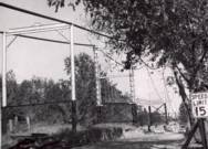
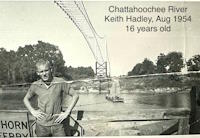
1927: Neals Landing
Neals Landing, Donalsonville vicinity, Georgia and Jackson County, Florida, USA - Chattahoochee River
| Bridgemeister ID: | 2145 (added 2006-11-05) |
| Year Completed: | 1927 |
| Name: | Neals Landing |
| Location: | Neals Landing, Donalsonville vicinity, Georgia and Jackson County, Florida, USA |
| Crossing: | Chattahoochee River |
| Coordinates: | 30.977306 N 85.006000 W |
| Maps: | Acme, GeoHack, Google, OpenStreetMap |
| Principals: | Austin Bridge Co. |
| References: | PTS2, RRC |
| Use: | Vehicular |
| Status: | Removed, c. 1954 |
| Main Cables: | Wire (steel) |
| Suspended Spans: | 3 |
| Main Span: | 1 |
| Side Spans: | 2 |
Notes:
- Condemned, 1953, due to sinking foundation.
- Follow the image for more information about this bridge and location.
Image Sets:


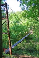
1977: Toccoa River
Dahlonega vicinity, Georgia, USA - Toccoa River
| Bridgemeister ID: | 250 (added before 2003) |
| Year Completed: | 1977 |
| Name: | Toccoa River |
| Also Known As: | Swinging |
| Location: | Dahlonega vicinity, Georgia, USA |
| Crossing: | Toccoa River |
| At or Near Feature: | Benton MacKaye Trail |
| Coordinates: | 34.736857 N 84.167320 W |
| Maps: | Acme, GeoHack, Google, OpenStreetMap |
| Use: | Footbridge |
| Status: | In use (last checked: 2018) |
| Main Cables: | Wire (steel) |
| Main Span: | 1 x 80.8 meters (265 feet) |
2002: Tallulah Gorge
Tallulah Gorge State Park, Georgia, USA - Tallulah River
| Bridgemeister ID: | 605 (added 2003-01-14) |
| Year Completed: | 2002 |
| Name: | Tallulah Gorge |
| Location: | Tallulah Gorge State Park, Georgia, USA |
| Crossing: | Tallulah River |
| At or Near Feature: | Hurricane Falls |
| Coordinates: | 34.7387 N 83.391467 W |
| Maps: | Acme, GeoHack, Google, OpenStreetMap |
| Use: | Footbridge |
| Status: | In use (last checked: 2007) |
| Main Cables: | Wire (steel) |
| Main Span: | 1 x 76.2 meters (250 feet) estimated |
External Links:
2005: (footbridge)
Gainesville, Georgia, USA - Walnut Creek
| Bridgemeister ID: | 2462 (added 2008-09-27) |
| Year Completed: | 2005 |
| Name: | (footbridge) |
| Location: | Gainesville, Georgia, USA |
| Crossing: | Walnut Creek |
| At or Near Feature: | Elachee Nature Center |
| Coordinates: | 34.233920 N 83.831655 W |
| Maps: | Acme, GeoHack, Google, OpenStreetMap |
| Use: | Footbridge |
| Status: | In use (last checked: 2018) |
| Main Cables: | Wire (steel) |
| Main Span: | 1 |
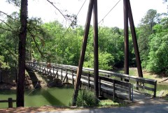
2008: Lullwater Preserve
Decatur, Georgia, USA - Peachtree Creek
| Bridgemeister ID: | 2452 (added 2008-08-11) |
| Year Completed: | 2008 |
| Name: | Lullwater Preserve |
| Location: | Decatur, Georgia, USA |
| Crossing: | Peachtree Creek |
| At or Near Feature: | Emory University |
| Coordinates: | 33.80195 N 84.31518 W |
| Maps: | Acme, GeoHack, Google, OpenStreetMap |
| Principals: | Sahale, LLC |
| Use: | Footbridge |
| Status: | In use (last checked: 2008) |
| Main Cables: | Wire (steel) |
| Main Span: | 1 x 64 meters (210 feet) |
Image Sets:

| Bridgemeister ID: | 2666 (added 2019-03-15) |
| Year Completed: | 2009 |
| Name: | Rock Springs |
| Location: | Lawrenceville, Georgia, USA |
| At or Near Feature: | Rock Springs Park |
| Principals: | Sahale LLC |
| Use: | Footbridge |
| Status: | In use (last checked: 2009) |
| Main Cables: | Wire (steel) |
| Suspended Spans: | 1 |
| Main Span: | 1 x 30.5 meters (100 feet) |
External Links:
2014: King Mill Tailrace
Augusta, Georgia, USA - King Mill Tailrace
| Bridgemeister ID: | 5841 (added 2021-05-13) |
| Year Completed: | 2014 |
| Name: | King Mill Tailrace |
| Location: | Augusta, Georgia, USA |
| Crossing: | King Mill Tailrace |
| At or Near Feature: | River Levee Trail |
| Coordinates: | 33.486881 N 81.988253 W |
| Maps: | Acme, GeoHack, Google, OpenStreetMap |
| Use: | Footbridge |
| Status: | In use (last checked: 2021) |
| Main Cables: | Wire (steel) |
| Suspended Spans: | 1 |
| Main Span: | 1 x 57.9 meters (190 feet) |
(footbridge)
Bobby Brown State Park, Georgia, USA - Clarks Hill Lake arm
| Bridgemeister ID: | 2235 (added 2007-03-19) |
| Name: | (footbridge) |
| Location: | Bobby Brown State Park, Georgia, USA |
| Crossing: | Clarks Hill Lake arm |
| Coordinates: | 33.97296 N 82.57752 W |
| Maps: | Acme, GeoHack, Google, OpenStreetMap |
| Use: | Footbridge |
| Status: | In use (last checked: 2011) |
| Main Cables: | Wire (steel) |
| Suspended Spans: | 1 |
Image Sets:

(footbridge)
Ellijay, Georgia, USA - Coosawattee River
| Bridgemeister ID: | 2461 (added 2008-09-27) |
| Name: | (footbridge) |
| Location: | Ellijay, Georgia, USA |
| Crossing: | Coosawattee River |
| At or Near Feature: | Coosawattee River Resort |
| Coordinates: | 34.674655 N 84.529773 W |
| Maps: | Acme, GeoHack, Google, OpenStreetMap |
| Use: | Footbridge |
| Status: | In use (last checked: 2021) |
| Main Cables: | Wire (steel) |
| Suspended Spans: | 3 |
| Main Span: | 1 x 45 meters (147.6 feet) estimated |
| Side Spans: | 1, 1 |
Morningside Nature Preserve
Atlanta, Georgia, USA - South Fork Peachtree Creek
| Bridgemeister ID: | 2703 (added 2019-06-15) |
| Name: | Morningside Nature Preserve |
| Location: | Atlanta, Georgia, USA |
| Crossing: | South Fork Peachtree Creek |
| Coordinates: | 33.805718 N 84.356140 W |
| Maps: | Acme, GeoHack, Google, OpenStreetMap |
| Use: | Footbridge |
| Status: | In use (last checked: 2019) |
| Main Cables: | Wire (steel) |
| Suspended Spans: | 1 |
Swinging
Cloudland, Georgia, USA - East Fork Little River
| Bridgemeister ID: | 359 (added before 2003) |
| Name: | Swinging |
| Location: | Cloudland, Georgia, USA |
| Crossing: | East Fork Little River |
| Coordinates: | 34.532512 N 85.482169 W |
| Maps: | Acme, GeoHack, Google, OpenStreetMap |
| Use: | Footbridge |
| Status: | Extant (last checked: 2019) |
| Main Cables: | Wire |
Do you have any information or photos for these bridges that you would like to share? Please email david.denenberg@bridgemeister.com.
Mail | Facebook | X (Twitter) | Bluesky