Suspension Bridges Crossing White River
This is a list of all 5 bridges from the suspension bridge inventory crossing White River. Please note that different rivers with the same name will be grouped together. For example, selecting 'Bear Creek' shows bridges across several different Bear Creeks. Also, similarly named rivers are grouped separately. For example, 'River Dee' (UK) bridges are grouped separately from 'Dee River' (Australia) bridges. Wherever you see a Bridgemeister ID number click it to isolate the bridge on its own page.
Related Lists:
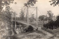
1892: (footbridge)
Anderson, Indiana, USA - White River
| Bridgemeister ID: | 6467 (added 2021-08-13) |
| Year Completed: | 1892 |
| Name: | (footbridge) |
| Location: | Anderson, Indiana, USA |
| Crossing: | White River |
| Use: | Footbridge |
| Status: | Destroyed, March 27, 1921 |
| Main Cables: | Wire (steel) |
| Suspended Spans: | 3 |
| Main Span: | 1 |
| Side Spans: | 2 |
Annotated Citations:
- Jackson, Stephen T. "If the River Could Talk: Bridges at 27 sites." The Herald Bulletin., 3 July 2016, www.heraldbulletin.com/community/if-the-river-could-talk-bridges-at-27-sites/article_0141fb64-6416-526d-baa4-752e97f65b95.html
"Opened March 7, 1892, in what would today be the shadow of the Eisenhower Bridge, was a suspension bridge built to carry pedestrian traffic from Anderson to Park Place. Twin support towers at each end of the bridge held the suspension span in between… The fun lasted until a flood brought it down March 27, 1921."
External Links:
1901: Cold Spring
Indianapolis, Indiana, USA - White River
| Bridgemeister ID: | 258 (added before 2003) |
| Year Completed: | 1901 |
| Name: | Cold Spring |
| Also Known As: | Riverside Park |
| Location: | Indianapolis, Indiana, USA |
| Crossing: | White River |
| At or Near Feature: | Riverside Park |
| Coordinates: | 39.794516 N 86.200894 W |
| Maps: | Acme, GeoHack, Google, OpenStreetMap |
| Use: | Footbridge |
| Status: | Destroyed, 1918 |
| Main Cables: | Wire (steel) |
| Main Span: | 1 |
Notes:
- The southernmost of two similar suspension bridges built in 1901 in Indianapolis's Riverside Park.
- 1918: Destroyed by ice jam.
- Remnants of the tower piers are still present at this location as of the 2000s.
- Built as part of same project as 1901 Riverside Park - Indianapolis, Indiana, USA.
External Links:
- The History and Ruins of the Riverside Park Suspension Bridges. Details regarding the existence of, and remnants of, the two similar suspension bridges constructed in 1901 in Riverside Park.
Image Sets:


1901: Riverside Park
Indianapolis, Indiana, USA - White River
| Bridgemeister ID: | 8580 (added 2024-05-18) |
| Year Completed: | 1901 |
| Name: | Riverside Park |
| Location: | Indianapolis, Indiana, USA |
| Crossing: | White River |
| At or Near Feature: | Riverside Park |
| Coordinates: | 39.803861 N 86.198278 W |
| Maps: | Acme, GeoHack, Google, OpenStreetMap |
| Use: | Footbridge |
| Status: | Removed, c. 1905-1913 |
| Main Cables: | Wire (steel) |
| Main Span: | 1 |
Notes:
- The northernmost of two suspension bridges constructed in Indianapolis's Riverside Park in 1901.
- 1904: Damaged by ice jam.
- 1905: Again damaged by ice jam.
- Removed at some point prior to 1913. Remnants of the tower piers and anchorages are still present as of the 2020s at this location. Anchorage remnants are clearly visible from the White River boat ramp parking lot.
- Built as part of same project as 1901 Cold Spring (Riverside Park) - Indianapolis, Indiana, USA.
External Links:
- The History and Ruins of the Riverside Park Suspension Bridges. Details regarding the existence of, and remnants of, the two similar suspension bridges constructed in 1901 in Riverside Park.
Image Sets:


1928: Des Arc
Des Arc, Arkansas, USA - White River
| Bridgemeister ID: | 152 (added before 2003) |
| Year Completed: | 1928 |
| Name: | Des Arc |
| Also Known As: | Swinging |
| Location: | Des Arc, Arkansas, USA |
| Crossing: | White River |
| Coordinates: | 34.974811 N 91.487684 W |
| Maps: | Acme, GeoHack, Google, OpenStreetMap |
| Principals: | Austin Bridge Co |
| References: | AUB, PTS2 |
| Use: | Vehicular |
| Status: | Demolished, August 1970 |
| Main Cables: | Wire (steel) |
| Suspended Spans: | 3 |
| Main Span: | 1 x 198.1 meters (650 feet) |
| Side Spans: | 2 x 97.5 meters (320 feet) |
Notes:
- The coordinates provided here indicate the approximate alignment of the bridge, about 0.5 miles southeast of the current (2020s) Des Arc White River crossing. The bridge delivered traffic near the east end of East Chester Street in Des Arc.
External Links:
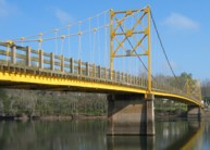
1949: Beaver
Beaver, Arkansas, USA - White River
| Bridgemeister ID: | 200 (added before 2003) |
| Year Completed: | 1949 |
| Name: | Beaver |
| Location: | Beaver, Arkansas, USA |
| Crossing: | White River |
| At or Near Feature: | Table Rock Reservoir |
| Coordinates: | 36.4708 N 93.76856 W |
| Maps: | Acme, GeoHack, Google, OpenStreetMap |
| Principals: | Pioneer Construction Co., Arkansas State Highway Department |
| Use: | Vehicular (one-lane) |
| Status: | Closed, October, 2021 (last checked: 2021) |
| Main Cables: | Wire (steel) |
| Suspended Spans: | 3 |
| Main Span: | 1 x 95.1 meters (312 feet) |
| Side Spans: | 2 x 32 meters (105 feet) |
| Deck width: | 11.1 feet |
Notes:
- 1981: Deck replaced.
- 1990: Added to National Register of Historic Places
- 2002: Deck replaced.
- 2020: Timber deck and railings replaced, September.
- 2021, October: Closed again for repairs.
External Links:
- Historic Bridges of the United States - Beaver Bridge - Carroll County, Arkansas. States bridge was completed in 1949.
- Structurae - Structure ID 20012249
Image Sets:

Do you have any information or photos for these bridges that you would like to share? Please email david.denenberg@bridgemeister.com.
Mail | Facebook | X (Twitter) | Bluesky