Suspension Bridges of Quebec
This is a list of all 37 bridges from the suspension bridge inventory for Quebec in Canada. Wherever you see a Bridgemeister ID number click it to isolate the bridge on its own page.
Related Lists:
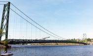
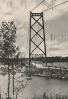
1929: Grand Mère
Grand-Mère, Quebec, Canada - St. Maurice River
| Bridgemeister ID: | 162 (added before 2003) |
| Year Completed: | 1929 |
| Name: | Grand Mère |
| Location: | Grand-Mère, Quebec, Canada |
| Crossing: | St. Maurice River |
| Coordinates: | 46.620117 N 72.6794 W |
| Maps: | Acme, GeoHack, Google, OpenStreetMap |
| Principals: | Robinson and Steinman |
| References: | AAJ, BC3, BPL, PTS2, SJR |
| Use: | Vehicular (two-lane, heavy vehicles), with walkway |
| Status: | In use (last checked: 2019) |
| Main Cables: | Wire (steel) |
| Suspended Spans: | 1 |
| Main Span: | 1 x 289.2 meters (948.8 feet) |
| Deck width: | 26 feet |
External Links:
1935: l'Île d'Orléans
Quebec City, Quebec, Canada - St. Lawrence River
| Bridgemeister ID: | 183 (added before 2003) |
| Year Completed: | 1935 |
| Name: | l'Île d'Orléans |
| Also Known As: | Isle of Orleans, Orleans Island, Taschereau |
| Location: | Quebec City, Quebec, Canada |
| Crossing: | St. Lawrence River |
| Coordinates: | 46.880233 N 71.137883 W |
| Maps: | Acme, GeoHack, Google, OpenStreetMap |
| Principals: | Monsarrat and Pratley |
| References: | AAJ |
| Use: | Vehicular (two-lane, heavy vehicles), with walkway |
| Status: | In use (last checked: 2019) |
| Main Cables: | Wire (steel) |
| Suspended Spans: | 3 |
| Main Span: | 1 x 323 meters (1,059.7 feet) |
| Side Spans: | 2 x 127 meters (416.7 feet) |
| Deck width: | 30 feet |
Notes:
- Replacement proposed to start in 2024.
- Near Montmorency Falls - Quebec City vicinity, Quebec, Canada.
External Links:

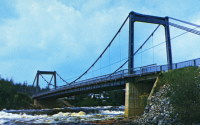
1939: Chute du Brule
Grand-Remous, Quebec, Canada - Gatineau River
| Bridgemeister ID: | 192 (added before 2003) |
| Year Completed: | 1939 |
| Name: | Chute du Brule |
| Location: | Grand-Remous, Quebec, Canada |
| Crossing: | Gatineau River |
| Principals: | Dominion Bridge Co. |
| Use: | Vehicular (two-lane) |
| Status: | Removed |
| Main Cables: | Wire (steel) |
| Suspended Spans: | 1 |
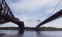
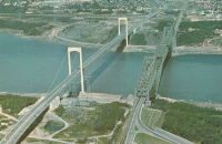
1970: Pierre Laporte
Quebec City and Levis, Quebec, Canada - St. Lawrence River
| Bridgemeister ID: | 228 (added before 2003) |
| Year Completed: | 1970 |
| Name: | Pierre Laporte |
| Location: | Quebec City and Levis, Quebec, Canada |
| Crossing: | St. Lawrence River |
| Coordinates: | 46.741717 N 71.288333 W |
| Maps: | Acme, GeoHack, Google, OpenStreetMap |
| Principals: | Demers-Vandry-Grondquist |
| Use: | Vehicular (major highway) |
| Status: | In use (last checked: 2023) |
| Main Cables: | Wire (steel) |
| Suspended Spans: | 3 |
| Main Span: | 1 x 667.5 meters (2,190 feet) |
| Side Spans: | 2 x 186.5 meters (611.9 feet) |
Notes:
- 2021, November: Weight and lane restrictions imposed pending urgent replacement of several suspender cables.
External Links:
- CBC - Suspension cables on Quebec City's Pierre-Laporte bridge could give way at any time, report finds. June 16, 2022. Article reporting the alarming amount of corrosion found in the bridge's cables. Immediate repairs are recommended.
- Pierre Laporte Bridge - Wikipedia
- Structurae - Structure ID 20003362
1974: Mestachibo
Beaupré, Quebec, Canada - Sainte-Anne River
| Bridgemeister ID: | 231 (added before 2003) |
| Year Completed: | 1974 |
| Name: | Mestachibo |
| Location: | Beaupré, Quebec, Canada |
| Crossing: | Sainte-Anne River |
| At or Near Feature: | Canyon Sainte-Anne |
| Coordinates: | 47.07486 N 70.87540 W |
| Maps: | Acme, GeoHack, Google, OpenStreetMap |
| Use: | Footbridge |
| Status: | In use (last checked: 2019) |
| Main Cables: | Wire (steel) |
| Suspended Spans: | 3 |
| Main Span: | 1 x 63 meters (206.7 feet) |
| Side Spans: | 2 |
1978: Bernier
Bromptonville, Sherbrooke vicinity, Quebec, Canada - St. François River
| Bridgemeister ID: | 1162 (added 2004-01-19) |
| Year Completed: | 1978 |
| Name: | Bernier |
| Location: | Bromptonville, Sherbrooke vicinity, Quebec, Canada |
| Crossing: | St. François River |
| Use: | Footbridge and Snowmobile |
| Status: | Replaced, 2001 |
| Main Cables: | Wire (steel) |
| Main Span: | 1 x 66 meters (216.5 feet) |
Notes:
- Carried Trans Canada Trail. Intended for pedestrians, cyclists, and snowmobiles.
- Replaced by 2001 Bernier - Bromptonville, Sherbrooke vicinity, Quebec, Canada.
1979: McNicoll
Beaupré, Quebec, Canada - Sainte-Anne River
| Bridgemeister ID: | 232 (added before 2003) |
| Year Completed: | 1979 |
| Name: | McNicoll |
| Location: | Beaupré, Quebec, Canada |
| Crossing: | Sainte-Anne River |
| At or Near Feature: | Canyon Sainte-Anne |
| Coordinates: | 47.07333 N 70.87749 W |
| Maps: | Acme, GeoHack, Google, OpenStreetMap |
| Use: | Footbridge |
| Status: | In use (last checked: 2019) |
| Main Cables: | Wire (steel) |
| Main Span: | 1 x 58 meters (190.3 feet) |
1988: Coaticook
Coaticook, Quebec, Canada - Coaticook River
| Bridgemeister ID: | 249 (added before 2003) |
| Year Completed: | 1988 |
| Name: | Coaticook |
| Location: | Coaticook, Quebec, Canada |
| Crossing: | Coaticook River |
| At or Near Feature: | Le Parc de la Gorge de Coaticook |
| Coordinates: | 45.145983 N 71.8112 W |
| Maps: | Acme, GeoHack, Google, OpenStreetMap |
| Use: | Footbridge |
| Status: | In use (last checked: 2023) |
| Main Cables: | Wire (steel) |
| Suspended Spans: | 2 |
| Main Span: | 1 x 114 meters (374 feet) estimated |
| Side Span: | 1 x 52.1 meters (171 feet) estimated |
Notes:
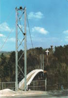
1995: Ville De Causapscal
Causapscal, Quebec, Canada - Matapédia River
| Bridgemeister ID: | 2593 (added 2014-04-14) |
| Year Completed: | 1995 |
| Name: | Ville De Causapscal |
| Location: | Causapscal, Quebec, Canada |
| Crossing: | Matapédia River |
| Use: | Snowmobile |
| Status: | In use (last checked: 2011) |
| Main Cables: | Wire (steel) |
| Suspended Spans: | 1 |
| Main Span: | 1 x 48.8 meters (160 feet) estimated |
Notes:
- Renovated 2010.
2001: Bernier
Bromptonville, Sherbrooke vicinity, Quebec, Canada - St. François River
| Bridgemeister ID: | 1163 (added 2004-01-19) |
| Year Completed: | 2001 |
| Name: | Bernier |
| Location: | Bromptonville, Sherbrooke vicinity, Quebec, Canada |
| Crossing: | St. François River |
| Coordinates: | 45.483752 N 71.960675 W |
| Maps: | Acme, GeoHack, Google, OpenStreetMap |
| Principals: | Canadian Military Engineers (CME) |
| Use: | Footbridge |
| Status: | Destroyed, January, 2018 |
| Main Cables: | Wire (steel) |
Notes:
- Destroyed by flood and ice jam, January 2018, along with the adjacent rail bridge.
- Replaced 1978 Bernier - Bromptonville, Sherbrooke vicinity, Quebec, Canada.
2009: (snowmobile bridge)
Saint-Martin, Quebec, Canada - Chaudière River
| Bridgemeister ID: | 2555 (added 2012-01-01) |
| Year Completed: | 2009 |
| Name: | (snowmobile bridge) |
| Location: | Saint-Martin, Quebec, Canada |
| Crossing: | Chaudière River |
| Coordinates: | 45.94855 N 70.65539 W |
| Maps: | Acme, GeoHack, Google, OpenStreetMap |
| Use: | Snowmobile |
| Status: | In use (last checked: 2010) |
| Main Cables: | Wire (steel) |
| Suspended Spans: | 1 |
| Main Span: | 1 x 109.7 meters (360 feet) |
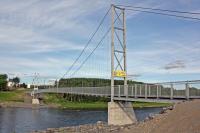
(footbridge)
Baie-Comeau vicinity, Quebec, Canada - Reservoir Manic Deaux
| Bridgemeister ID: | 1883 (added 2005-09-24) |
| Name: | (footbridge) |
| Location: | Baie-Comeau vicinity, Quebec, Canada |
| Crossing: | Reservoir Manic Deaux |
| Coordinates: | 49.202117 N 68.34245 W |
| Maps: | Acme, GeoHack, Google, OpenStreetMap |
| Use: | Footbridge and Snowmobile |
| Status: | In use (last checked: 2005) |
| Main Cables: | Wire (steel) |
| Suspended Spans: | 1 |
| Main Span: | 1 x 90 meters (295.3 feet) estimated |
| Bridgemeister ID: | 1318 (added 2004-04-25) |
| Name: | (footbridge) |
| Location: | Bout-du-Monde vicinity, Quebec, Canada |
| Coordinates: | 46.40765 N 73.07795 W |
| Maps: | Acme, GeoHack, Google, OpenStreetMap |
| Use: | Footbridge |
| Status: | In use (last checked: 2005) |
| Main Cables: | Wire |
| Suspended Spans: | 1 |
Notes:
- Tall timber towers, possibly made from telephone poles.
(footbridge)
Causapscal, Quebec, Canada - Matapédia River
| Bridgemeister ID: | 2594 (added 2014-04-14) |
| Name: | (footbridge) |
| Location: | Causapscal, Quebec, Canada |
| Crossing: | Matapédia River |
| Coordinates: | 48.352598 N 67.223151 W |
| Maps: | Acme, GeoHack, Google, OpenStreetMap |
| Use: | Footbridge |
| Status: | In use (last checked: 2018) |
| Main Cables: | Wire (steel) |
| Suspended Spans: | 3 |
| Main Span: | 1 x 48.8 meters (160 feet) estimated |
| Side Spans: | 1 x 6.1 meters (20 feet) estimated, 1 x 4.6 meters (15 feet) estimated |
(footbridge)
Coaticook, Quebec, Canada - Coaticook River
| Bridgemeister ID: | 2588 (added 2014-04-14) |
| Name: | (footbridge) |
| Location: | Coaticook, Quebec, Canada |
| Crossing: | Coaticook River |
| At or Near Feature: | Le Parc de la Gorge de Coaticook |
| Use: | Footbridge |
| Status: | In use (last checked: 2011) |
| Main Cables: | Wire |
| Suspended Spans: | 1 |
| Main Span: | 1 x 19.8 meters (65 feet) estimated |
Notes:
(footbridge)
Joliette, Quebec, Canada - L'Assomption River
| Bridgemeister ID: | 1741 (added 2005-04-20) |
| Name: | (footbridge) |
| Location: | Joliette, Quebec, Canada |
| Crossing: | L'Assomption River |
| Coordinates: | 46.0082 N 73.419917 W |
| Maps: | Acme, GeoHack, Google, OpenStreetMap |
| Use: | Footbridge |
| Status: | In use (last checked: 2018) |
| Main Cables: | Wire (steel) |
(footbridge)
Nouvelle, Quebec, Canada - Nouvelle River
| Bridgemeister ID: | 1887 (added 2005-09-24) |
| Name: | (footbridge) |
| Location: | Nouvelle, Quebec, Canada |
| Crossing: | Nouvelle River |
| Coordinates: | 48.130833 N 66.30605 W |
| Maps: | Acme, GeoHack, Google, OpenStreetMap |
| Use: | Footbridge and Snowmobile |
| Status: | In use (last checked: 2005) |
| Main Cables: | Wire |
(footbridge)
Port-Daniel, Quebec, Canada - Petite Rivière Port-Daniel
| Bridgemeister ID: | 1407 (added 2004-07-04) |
| Name: | (footbridge) |
| Location: | Port-Daniel, Quebec, Canada |
| Crossing: | Petite Rivière Port-Daniel |
| Coordinates: | 48.177817 N 64.971483 W |
| Maps: | Acme, GeoHack, Google, OpenStreetMap |
| Use: | Footbridge |
| Status: | In use (last checked: 2004) |
| Main Cables: | Wire (steel) |
| Suspended Spans: | 1 |
(footbridge)
Saint-Juste-du-Lac, Quebec, Canada - Touladi River
| Bridgemeister ID: | 2589 (added 2014-04-14) |
| Name: | (footbridge) |
| Location: | Saint-Juste-du-Lac, Quebec, Canada |
| Crossing: | Touladi River |
| Coordinates: | 47.675142 N 68.795619 W |
| Maps: | Acme, GeoHack, Google, OpenStreetMap |
| Use: | Footbridge |
| Status: | In use (last checked: 2019) |
| Main Cables: | Wire (steel) |
| Suspended Spans: | 1 |
| Main Span: | 1 x 48.8 meters (160 feet) estimated |
| Bridgemeister ID: | 1712 (added 2005-04-03) |
| Name: | (footbridge) |
| Location: | St-Norbert-de-Mont-Brun vicinity, Quebec, Canada |
| At or Near Feature: | Parc d'Aiguebelle |
| Coordinates: | 48.463686 N 78.702162 W |
| Maps: | Acme, GeoHack, Google, OpenStreetMap |
| Use: | Footbridge |
| Status: | In use (last checked: 2013) |
| Main Cables: | Wire (steel) |
| Suspended Spans: | 1 |
(snowmobile bridge)
Causapscal, Quebec, Canada - Causapscal River
| Bridgemeister ID: | 2592 (added 2014-04-14) |
| Name: | (snowmobile bridge) |
| Location: | Causapscal, Quebec, Canada |
| Crossing: | Causapscal River |
| Use: | Snowmobile |
| Status: | In use (last checked: 2011) |
| Main Cables: | Wire (steel) |
| Suspended Spans: | 1 |
| Main Span: | 1 x 51.8 meters (170 feet) estimated |
(suspension bridge)
Saint-Alexis-des-Monts vicinity, Quebec, Canada - Loup River
| Bridgemeister ID: | 1788 (added 2005-05-17) |
| Name: | (suspension bridge) |
| Location: | Saint-Alexis-des-Monts vicinity, Quebec, Canada |
| Crossing: | Loup River |
| Coordinates: | 46.56165 N 73.144883 W |
| Maps: | Acme, GeoHack, Google, OpenStreetMap |
Beauharnois
Melocheville, Quebec, Canada - St. Lawrence River
| Bridgemeister ID: | 1146 (added 2004-01-17) |
| Name: | Beauharnois |
| Location: | Melocheville, Quebec, Canada |
| Crossing: | St. Lawrence River |
| Coordinates: | 45.316050 N 73.908033 W |
| Maps: | Acme, GeoHack, Google, OpenStreetMap |
| Use: | Vehicular (two-lane, heavy vehicles), with walkway |
| Status: | In use (last checked: 2018) |
| Main Cables: | Wire (steel) |
| Suspended Spans: | 1 |
Notes:
- Carries route 132 across a small arm of the St. Lawrence by the Canal de Beauharnois dam.
- Major rehabilitation efforts completed in 2011 and 2012 including replacement of 56 vertical suspenders.
External Links:
Chaudière River
Charny, Quebec, Canada - Chaudière River
| Bridgemeister ID: | 247 (added before 2003) |
| Name: | Chaudière River |
| Location: | Charny, Quebec, Canada |
| Crossing: | Chaudière River |
| Coordinates: | 46.717350 N 71.285937 W |
| Maps: | Acme, GeoHack, Google, OpenStreetMap |
| Use: | Footbridge |
| Status: | In use (last checked: 2019) |
| Main Cables: | Wire (steel) |
Notes:
- Long footbridge.
- Near 1970 Pierre Laporte - Quebec City and Levis, Quebec, Canada. The Pierre Laporte and Quebec Cantilever bridges are visible in the distance from this footbridge.
Club Les Chevaliers De La Motoneige
New Richmond, Quebec, Canada - Little Cascapedia River
| Bridgemeister ID: | 2595 (added 2014-04-14) |
| Name: | Club Les Chevaliers De La Motoneige |
| Location: | New Richmond, Quebec, Canada |
| Crossing: | Little Cascapedia River |
| Use: | Snowmobile |
| Status: | In use (last checked: 2011) |
| Main Cables: | Wire (steel) |
| Suspended Spans: | 1 |
| Main Span: | 1 x 79.9 meters (262 feet) estimated |
Des Chutes Du Ruisseau Creux
Saint-Alphonse-de-Caplan, Quebec, Canada - Bonaventure River
| Bridgemeister ID: | 2596 (added 2014-04-14) |
| Name: | Des Chutes Du Ruisseau Creux |
| Location: | Saint-Alphonse-de-Caplan, Quebec, Canada |
| Crossing: | Bonaventure River |
| Coordinates: | 48.192363 N 65.563592 W |
| Maps: | Acme, GeoHack, Google, OpenStreetMap |
| Use: | Snowmobile and Footbridge |
| Status: | In use (last checked: 2018) |
| Main Cables: | Wire (steel) |
| Suspended Spans: | 1 |
| Main Span: | 1 x 79.2 meters (260 feet) estimated |
Forêt Ouareau
Notre-Dame-de-la-Merci, Quebec, Canada - Ouareau River
| Bridgemeister ID: | 2423 (added 2008-03-02) |
| Name: | Forêt Ouareau |
| Location: | Notre-Dame-de-la-Merci, Quebec, Canada |
| Crossing: | Ouareau River |
| At or Near Feature: | Ouareau Forest |
| Coordinates: | 46.252520 N 73.974730 W |
| Maps: | Acme, GeoHack, Google, OpenStreetMap |
| Use: | Snowmobile |
| Status: | In use (last checked: 2020) |
| Main Cables: | Wire (steel) |
Gervais Lacasse
Causapscal vicinity, Quebec, Canada - Assemetquagan River
| Bridgemeister ID: | 2591 (added 2014-04-14) |
| Name: | Gervais Lacasse |
| Location: | Causapscal vicinity, Quebec, Canada |
| Crossing: | Assemetquagan River |
| Use: | ATV and Footbridge |
| Status: | In use (last checked: 2011) |
| Main Cables: | Wire (steel) |
| Suspended Spans: | 1 |
| Main Span: | 1 x 36.6 meters (120 feet) estimated |
Jean-Luc Sylvain
Quebec City, Quebec, Canada - Montmorency River
| Bridgemeister ID: | 2727 (added 2019-06-22) |
| Name: | Jean-Luc Sylvain |
| Location: | Quebec City, Quebec, Canada |
| Crossing: | Montmorency River |
| Coordinates: | 46.927142 N 71.193853 W |
| Maps: | Acme, GeoHack, Google, OpenStreetMap |
| Use: | Snowmobile and ATV |
| Status: | In use (last checked: 2019) |
| Main Cables: | Wire (steel) |
La Tuque
La Tuque, Quebec, Canada - St. Maurice River
| Bridgemeister ID: | 1628 (added 2005-03-11) |
| Name: | La Tuque |
| Location: | La Tuque, Quebec, Canada |
| Crossing: | St. Maurice River |
| Coordinates: | 47.449433 N 72.797383 W |
| Maps: | Acme, GeoHack, Google, OpenStreetMap |
| Use: | Vehicular (one-lane) |
| Status: | In use (last checked: 2022) |
| Main Cables: | Wire (steel) |
| Suspended Spans: | 1 |
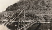
| Bridgemeister ID: | 2553 (added 2012-01-01) |
| Name: | Louis-Marie Gagnon |
| Location: | Grand-Fonds vicinity, Quebec, Canada |
| Coordinates: | 49.04213 N 66.69042 W |
| Maps: | Acme, GeoHack, Google, OpenStreetMap |
| Use: | Snowmobile |
| Status: | In use (last checked: 2010) |
| Main Cables: | Wire (steel) |
| Suspended Spans: | 1 |
Notes:
- Sign at bridge says "Passerelle - Louis-Marie Gagnon - Cap-Chat 2000"
Montmorency Falls
Quebec City vicinity, Quebec, Canada - Montmorency Falls
| Bridgemeister ID: | 1418 (added 2004-07-17) |
| Name: | Montmorency Falls |
| Location: | Quebec City vicinity, Quebec, Canada |
| Crossing: | Montmorency Falls |
| Coordinates: | 46.890964 N 71.147429 W |
| Maps: | Acme, GeoHack, Google, OpenStreetMap |
| Use: | Footbridge |
| Status: | In use (last checked: 2021) |
| Main Cables: | Wire (steel) |
| Suspended Spans: | 1 |
Notes:
- This bridge allows tourists to walk above Montmorency Falls. The current towers are built to resemble the Isle Of Orleans bridge which is clearly visible from the falls. Stone towers from the previous suspension bridge are still present next to the current towers.
- At former location of Montmorency Falls - Quebec City vicinity, Quebec, Canada.
- Near 1935 l'Île d'Orléans (Isle of Orleans, Orleans Island, Taschereau) - Quebec City, Quebec, Canada.
External Links:
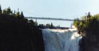
Montmorency Falls
Quebec City vicinity, Quebec, Canada - Montmorency Falls
| Bridgemeister ID: | 1526 (added 2004-10-24) |
| Name: | Montmorency Falls |
| Location: | Quebec City vicinity, Quebec, Canada |
| Crossing: | Montmorency Falls |
| Coordinates: | 46.890706 N 71.147952 W |
| Maps: | Acme, GeoHack, Google, OpenStreetMap |
| References: | AAJ, HBE |
| Use: | Vehicular |
| Status: | Failed, April 30, 1856 |
| Main Cables: | Wire (iron) |
| Suspended Spans: | 1 |
Notes:
- Towers from this bridge are still visible next to the towers of the current suspension footbridge. HBE, in 1911, notes that it "collapsed some years ago carrying a wagon and its driver into the cataract."
- Jakkula (AAJ) cites an article tracing back to the Quebec Gazette stating the bridge failed on April 30, 1856 resulting in the loss of "several" lives and recounting the troubled history of the bridge: "There had been statements made before to the effect that the bridge was not to be trusted. People crossed it with terror. On the northern bank, 5 of the 7 strands of one of the wire cables had previously given way, and the cable had been repaired."
- Later at same location Montmorency Falls - Quebec City vicinity, Quebec, Canada.
Passerelle 132
Amqui, Quebec, Canada - Matapédia River
| Bridgemeister ID: | 2590 (added 2014-04-14) |
| Name: | Passerelle 132 |
| Location: | Amqui, Quebec, Canada |
| Crossing: | Matapédia River |
| Use: | Snowmobile and Footbridge |
| Status: | In use (last checked: 2011) |
| Main Cables: | Wire |
| Suspended Spans: | 1 |
| Main Span: | 1 x 50.9 meters (167 feet) estimated |
Do you have any information or photos for these bridges that you would like to share? Please email david.denenberg@bridgemeister.com.