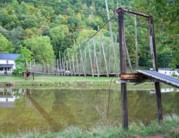
Suspension Bridges Crossing South Branch Potomac River
This is a list of all 4 bridges from the suspension bridge inventory crossing South Branch Potomac River. Please note that different rivers with the same name will be grouped together. For example, selecting 'Bear Creek' shows bridges across several different Bear Creeks. Also, similarly named rivers are grouped separately. For example, 'River Dee' (UK) bridges are grouped separately from 'Dee River' (Australia) bridges. Wherever you see a Bridgemeister ID number click it to isolate the bridge on its own page.
Related Lists:
(footbridge)
Franklin vicinity and Cave vicinity, West Virginia, USA - South Branch Potomac River
| Bridgemeister ID: | 2385 (added 2007-11-18) |
| Name: | (footbridge) |
| Location: | Franklin vicinity and Cave vicinity, West Virginia, USA |
| Crossing: | South Branch Potomac River |
| Coordinates: | 38.60056 N 79.37812 W |
| Maps: | Acme, GeoHack, Google, OpenStreetMap |
| Use: | Footbridge |
| Status: | In use (last checked: 2007) |
| Main Cables: | Wire |
| Suspended Spans: | 1 |
| Main Span: | 1 x 42.1 meters (138 feet) |

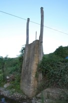
(suspension bridge)
Franklin, West Virginia, USA - South Branch Potomac River
| Bridgemeister ID: | 4924 (added 2020-07-27) |
| Name: | (suspension bridge) |
| Location: | Franklin, West Virginia, USA |
| Crossing: | South Branch Potomac River |
| Coordinates: | 38.639645 N 79.332320 W |
| Maps: | Acme, GeoHack, Google, OpenStreetMap |
| Status: | Only towers remain (last checked: 2015) |
| Main Cables: | Wire |
External Links:

Sector
Sector, Romney, West Virginia, USA - South Branch Potomac River
| Bridgemeister ID: | 4922 (added 2020-07-26) |
| Name: | Sector |
| Location: | Sector, Romney, West Virginia, USA |
| Crossing: | South Branch Potomac River |
| Coordinates: | 39.227030 N 78.853329 W |
| Maps: | Acme, GeoHack, Google, OpenStreetMap |
| References: | AAJ |
| Use: | Vehicular |
| Status: | Removed |
| Main Cables: | Wire |
| Suspended Spans: | 2 |
| Main Spans: | 1 x 18.3 meters (60 feet), 1 x 27.4 meters (90 feet) |
Notes:
- Coordinates are approximate location of this bridge, believed to be where present day (2020) Fleming-Sector Road would have continued to intersect the river. Location was also known as Glebe Station.
External Links:
Wire
Grace, Springfield, West Virginia, USA - South Branch Potomac River
| Bridgemeister ID: | 4921 (added 2020-07-26) |
| Name: | Wire |
| Location: | Grace, Springfield, West Virginia, USA |
| Crossing: | South Branch Potomac River |
| Coordinates: | 39.427319 N 78.714996 W |
| Maps: | Acme, GeoHack, Google, OpenStreetMap |
| Use: | Vehicular |
| Status: | Removed |
| Main Cables: | Wire (iron) |
Notes:
- A Civil War skirmish known as the "Wire Bridge Engagement" occurred on October 24, 1861 at the location of the present day (2020) Grace crossing (John Blue Bridge). The bridge played a prominent role as the event unfolded on and around the bridge, described very specifically as a wire bridge. A historical marker at the site shows an illustration from the New York Illustrated News (1862) clearly showing a period-correct vehicular suspension bridge.
- This location was in Virginia at the time the bridge was completed (prior to 1861, presumably).
- Coordinates are of the present day (2020) crossing at this location, believed to be very close to the location of the suspension bridge, if not the same location.
Do you have any information or photos for these bridges that you would like to share? Please email david.denenberg@bridgemeister.com.