Suspension Bridges Crossing Missouri River
This is a list of all 7 bridges from the suspension bridge inventory crossing Missouri River. Please note that different rivers with the same name will be grouped together. For example, selecting 'Bear Creek' shows bridges across several different Bear Creeks. Also, similarly named rivers are grouped separately. For example, 'River Dee' (UK) bridges are grouped separately from 'Dee River' (Australia) bridges. Wherever you see a Bridgemeister ID number click it to isolate the bridge on its own page.
Related Lists:
1940: (pipeline bridge)
Sioux City, Iowa and Dakota City vicinity, Nebraska, USA - Missouri River
| Bridgemeister ID: | 2252 (added 2007-03-31) |
| Year Completed: | 1940 |
| Name: | (pipeline bridge) |
| Location: | Sioux City, Iowa and Dakota City vicinity, Nebraska, USA |
| Crossing: | Missouri River |
| Coordinates: | 42.43842 N 96.38387 W |
| Maps: | Acme, GeoHack, Google, OpenStreetMap |
| References: | AAJ |
| Use: | Pipeline |
| Status: | Removed, 2005 |
| Main Cables: | Wire (steel) |
| Main Span: | 1 x 404 meters (1,325.5 feet) estimated |
Notes:
- Large pipeline suspension bridge located near the Big Soo terminal.
External Links:
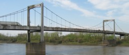
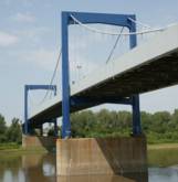
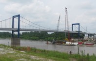
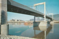
1953: Paseo
Kansas City, Missouri, USA - Missouri River
| Bridgemeister ID: | 636 (added 2003-02-02) |
| Year Completed: | 1953 |
| Name: | Paseo |
| Location: | Kansas City, Missouri, USA |
| Crossing: | Missouri River |
| Coordinates: | 39.122783 N 94.5661 W |
| Maps: | Acme, GeoHack, Google, OpenStreetMap |
| Use: | Vehicular (major highway) |
| Status: | Demolished, July, 2011 |
| Main Cables: | Wire (steel) |
| Suspended Spans: | 3 |
| Main Span: | 1 x 188.4 meters (618 feet) |
| Side Spans: | 2 |
| Characteristics: | Self-anchored |
Notes:
- Self-anchored. Carried I-29, I-35, and US71 across the Missouri River. Closed for several months in 2005 for major refurbishment. Reopened, September, 2005. Closed November, 2010. Demolished, July, 2011.
External Links:

1961: (pipeline bridge)
Jefferson vicinity, South Dakota and Ponca State Park, Nebraska, USA - Missouri River
| Bridgemeister ID: | 3809 (added 2020-03-01) |
| Year Completed: | 1961 |
| Name: | (pipeline bridge) |
| Location: | Jefferson vicinity, South Dakota and Ponca State Park, Nebraska, USA |
| Crossing: | Missouri River |
| Coordinates: | 42.593000 N 96.698267 W |
| Maps: | Acme, GeoHack, Google, OpenStreetMap |
| Use: | Pipeline |
| Status: | Removed, 2006 or 2007 |
| Main Cables: | Wire (steel) |
| Main Span: | 1 x 823 meters (2,700 feet) estimated |
Notes:
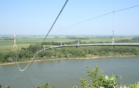
- Completed in 1961 or 1962. Removed in late 2006 or 2007.
- Replaced (pipeline bridge) - Jefferson vicinity, South Dakota and Ponca State Park, Nebraska, USA.
(footbridge)
Great Falls vicinity, Montana, USA - Missouri River
| Bridgemeister ID: | 2111 (added 2006-09-03) |
| Name: | (footbridge) |
| Location: | Great Falls vicinity, Montana, USA |
| Crossing: | Missouri River |
| At or Near Feature: | Ryan Island Day Use Area |
| Coordinates: | 47.568717 N 111.119083 W |
| Maps: | Acme, GeoHack, Google, OpenStreetMap |
| Use: | Footbridge |
| Status: | In use (last checked: 2006) |
| Main Cables: | Wire (steel) |
Notes:
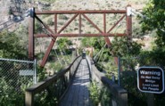
- Located just below Ryan Dam.
External Links:
(pipeline bridge)
Jefferson vicinity, South Dakota and Ponca State Park, Nebraska, USA - Missouri River
| Bridgemeister ID: | 646 (added 2003-02-17) |
| Name: | (pipeline bridge) |
| Location: | Jefferson vicinity, South Dakota and Ponca State Park, Nebraska, USA |
| Crossing: | Missouri River |
| Coordinates: | 42.60534 N 96.71001 W |
| Maps: | Acme, GeoHack, Google, OpenStreetMap |
| Use: | Pipeline |
| Status: | Removed |
| Main Cables: | Wire (steel) |
Notes:
- The postcard says "Suspension Bridge. Jefferson, S.D." The bridge pictured here may be a predecessor to the current pipeline suspension bridge at Ponca, Nebraska, eight miles west of Jefferson. Patrick S. O'Donnell visited this area in 2006 to photograph the Ponca bridge, but could not locate a pipeline bridge matching the postcard.
- In late 2006, Pete Rissell writes that one of the piers from this pipeline bridge is still visible in the middle of the Missouri River: "In the early 1970s I visited the Ponca State Park and noticed a single concrete bridge support in the middle of the Missouri River. I always thought it was strange because there were no abandoned road or rail right-of-ways in that location... I'm sure that this concrete support matches the one in the foreground shown on your website's postcard labeled "Suspension Bridge, Jefferson SD". My guess is that the current Ponca Pipeline bridge (photographed in 2006) is the replacement because the former suspension bridge had to be relocated due to river flooding. The old concrete support is located approximately 1 mile up-river (to the northwest) from the current pipeline bridge." This pier is visible in satellite imagery at the location provided with this inventory entry.
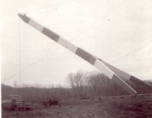
- In 2009, Dale Harkness writes: "I grew up on a farm only a few miles from the existing pipeline. I believe you are correct that the cement pier does belong to the original gas pipeline. My aunt told me that my grandfather was present while the bridge was being constructed. From my understanding, my grandfather had been filming the construction and almost photographed an unusual event where one of the piers crashed down to the ground after a failed attempt to raise it using a pivot." Dale also provided photos of the construction of the newer bridge in 1961.
- The replacement span appears to have been demolished in late 2006 or 2007.
- Replaced by 1961 (pipeline bridge) - Jefferson vicinity, South Dakota and Ponca State Park, Nebraska, USA.
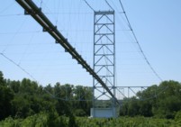
(pipeline bridge)
Plattsmouth, Nebraska and Pacific Junction vicinity, Iowa, USA - Missouri River
| Bridgemeister ID: | 2038 (added 2006-05-07) |
| Name: | (pipeline bridge) |
| Location: | Plattsmouth, Nebraska and Pacific Junction vicinity, Iowa, USA |
| Crossing: | Missouri River |
| Coordinates: | 41.0028 N 95.8679 W |
| Maps: | Acme, GeoHack, Google, OpenStreetMap |
| Use: | Pipeline |
| Status: | Extant (last checked: 2023) |
| Main Cables: | Wire (steel) |
| Suspended Spans: | 2 |
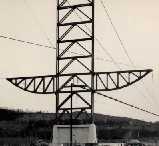
| Main Span: | 1 x 457.2 meters (1,500 feet) estimated |
| Side Span: | 1 x 228.6 meters (750 feet) estimated |
External Links:
Eagle Falls
Great Falls, Montana, USA - Missouri River
| Bridgemeister ID: | 6358 (added 2021-07-26) |
| Name: | Eagle Falls |
| Location: | Great Falls, Montana, USA |
| Crossing: | Missouri River |
| At or Near Feature: | Eagle Falls, Black Eagle Dam |
| Coordinates: | 47.519905 N 111.262229 W |
| Maps: | Acme, GeoHack, Google, OpenStreetMap |
| Use: | Footbridge |
| Status: | Destroyed, June 6, 1908 |
| Main Cables: | Wire (steel) |
| Main Span: | 1 |
| Side Span: | 1 |
Notes:
- Completed early 1890s.
- 1908, June: Destroyed by flood.
External Links:
- Black Eagle Dam - Wikipedia. From the article (retrieved 2021): "A 200-foot-long (61 m), 10-foot-wide (3.0 m) pedestrian suspension bridge ran from the bluffs above each powerhouse over the river." However, historic images of the bridge show it wa significantly longer with main and side spans of roughly 400 and 200 feet respectively.
- Bridgehunter.com | Eagle Falls Suspension Bridge
Do you have any information or photos for these bridges that you would like to share? Please email david.denenberg@bridgemeister.com.