Suspension Bridges Crossing Columbia River
This is a list of all 5 bridges from the suspension bridge inventory crossing Columbia River. Please note that different rivers with the same name will be grouped together. For example, selecting 'Bear Creek' shows bridges across several different Bear Creeks. Also, similarly named rivers are grouped separately. For example, 'River Dee' (UK) bridges are grouped separately from 'Dee River' (Australia) bridges. Wherever you see a Bridgemeister ID number click it to isolate the bridge on its own page.
Related Lists:
1919: Beebe
Beebe and Chelan, Washington, USA - Columbia River
| Bridgemeister ID: | 1188 (added 2004-01-24) |
| Year Completed: | 1919 |
| Name: | Beebe |
| Location: | Beebe and Chelan, Washington, USA |
| Crossing: | Columbia River |
| Coordinates: | 47.81308 N 119.97245 W |
| Maps: | Acme, GeoHack, Google, OpenStreetMap |
| Principals: | A. Munster, Wenatchee-Beebe Orchard Co. |
| References: | AAJ, PTS2, SPW |
| Use: | Pipeline and Vehicular |
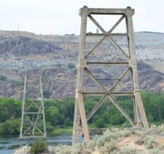
| Status: | Only towers remain, since 1963 (last checked: 2022) |
| Main Cables: | Wire (steel) |
| Suspended Spans: | 1 |
| Main Span: | 1 x 192.6 meters (632 feet) |
| Deck width: | 12 feet |
Notes:
- The towers are still standing next to the current US97 crossing at Beebe.
- AAJ: Private bridge, built primarily to carry water to the owner's orchard, but also carried a roadway.
External Links:
- The Beebe Bridge | Empire Press | wenatcheeworld.com. Article about the history of the bridge.
- Structurae - Structure ID 20052092

1935: Grand Coulee Dam
Grand Coulee, Washington, USA - Columbia River
| Bridgemeister ID: | 3157 (added 2019-11-03) |
| Year Completed: | 1935 |
| Name: | Grand Coulee Dam |
| Location: | Grand Coulee, Washington, USA |
| Crossing: | Columbia River |
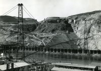
| Use: | Conveyor |
| Status: | Removed |
| Main Cables: | Wire (steel) |
| Main Span: | 1 x 438 meters (1,437 feet) |

1961: Revelstoke
Revelstoke, British Columbia, Canada - Columbia River
| Bridgemeister ID: | 943 (added 2003-10-29) |
| Year Completed: | 1961 |
| Name: | Revelstoke |
| Location: | Revelstoke, British Columbia, Canada |
| Crossing: | Columbia River |
| Coordinates: | 51.00713 N 118.2189 W |
| Maps: | Acme, GeoHack, Google, OpenStreetMap |
| Use: | Vehicular (two-lane, heavy vehicles), with walkway |
| Status: | In use (last checked: 2019) |
| Main Cables: | Wire (steel) |
| Suspended Spans: | 2 |
| Main Span: | 1 x 300.2 meters (985 feet) |
| Side Span: | 1 |
External Links:
1984: Zuckerberg Island Heritage Park
Castlegar, British Columbia, Canada - Columbia River
| Bridgemeister ID: | 913 (added 2003-10-11) |
| Year Completed: | 1984 |
| Name: | Zuckerberg Island Heritage Park |
| Location: | Castlegar, British Columbia, Canada |
| Crossing: | Columbia River |
| Coordinates: | 49.31616 N 117.65898 W |
| Maps: | Acme, GeoHack, Google, OpenStreetMap |
| Principals: | 44th Field Engineer Squadron |
| Use: | Footbridge |
| Status: | Closed (last checked: 2023) |
| Main Cables: | Wire (steel) |
| Suspended Spans: | 1 |
| Main Span: | 1 x 91.4 meters (300 feet) |
| Deck width: | 3 feet |
Notes:
- 2023, November: Has been closed for some time awaiting repairs.
- 1996: Bridge is reconstructed, according to sign posted at bridge.
- Near 1913 Brilliant (Doukhobor) - Castlegar vicinity, British Columbia, Canada.
2016: Columbia River Skywalk
Trail, British Columbia, Canada - Columbia River
| Bridgemeister ID: | 4957 (added 2020-08-09) |
| Year Completed: | 2016 |
| Name: | Columbia River Skywalk |
| Location: | Trail, British Columbia, Canada |
| Crossing: | Columbia River |
| Coordinates: | 49.094381 N 117.702046 W |
| Maps: | Acme, GeoHack, Google, OpenStreetMap |
| Principals: | COWI North America Ltd., Graham Infrastructure LP |
| Use: | Footbridge |
| Status: | In use (last checked: 2020) |
| Main Cables: | Wire (steel) |
| Suspended Spans: | 3 |
| Main Span: | 1 x 225 meters (738.2 feet) |
| Side Spans: | 2 |
External Links:
Do you have any information or photos for these bridges that you would like to share? Please email david.denenberg@bridgemeister.com.