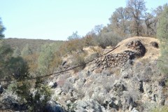
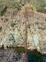
This is a single suspension bridge from the Bridgemeister historical inventory of suspension bridges.
1863: Lamb's
Latrobe vicinity and Plymouth vicinity, California, USA - Cosumnes River
| Bridgemeister ID: | 2117 (added 2006-09-10) |
| Year Completed: | 1863 |
| Name: | Lamb's |
| Location: | Latrobe vicinity and Plymouth vicinity, California, USA |
| Crossing: | Cosumnes River |
| Coordinates: | 38.52222 N 120.95587 W |
| Maps: | Acme, GeoHack, Google, OpenStreetMap |
| Use: | Vehicular (one-lane) |
| Status: | Derelict (last checked: 2020) |
| Main Cables: | Wire (iron) |
| Suspended Spans: | 1 |
Notes:
- The location coordinates provided here are the approximate location of this bridge, crossing the Cosumnes between present day El Dorado and Amador counties at Michigan Bar (as named on USGS topographical maps) on current Latrobe Road where Clark Creek meets the Cosumnes River. Note that USGS topographical maps show another, more prominently marked, "Michigan Bar" a few miles west in Sacramento County.
- A California Highways and Public Works article (unsure of exact citation but it may be the article on the history of California bridges that appeared in the 1941 June issue and was reprinted in the 1950 September/October issue) says "there were four [suspension bridges] on the Cosumnes River, one of which (Lamb's Bridge on the Latrobe-Plymouth Road) killed one man and seven horses when it fell in 1869."
- The October 14, 1976 edition of The Mountain Democrat Times (Placerville, California) has an article about the nearby Huse Bridge (from the Heritage Association of El Dorado) which mentions Lamb's Bridge: "...Lamb's Bridge, several miles downriver, was reconstructed in 1872 and was also a wire bridge of the same type [as Huse's]."
- The Statutes of California passed at the Fourteenth Session of the Legislature, 1863 records: "Chapter XLI. An Act to grant to Larkin Lamb and his Associates the right to construct and maintain a Toll Bridge across the Cosumnes River, in the Counties of Amador and El Dorado. Approved March 6, 1863. The People of the State of California, represented in Senate and Assembly, do enact as follows: Section 1. Larkin Lamb, and those he may associate with him, their heirs and assigns, shall have full power to build, erect, construct, and maintain a public toll bridge across the Cosumnes River, at a point about eighty (80) rods below Dutch Hill;..."
- A November 12, 2017 article in Ledger Dispatch (of Amador and Calaveras counties) titled "Vestiges of Amador-Communities Along the Cosumnes, Part VI: The Lower Reaches - Michigan Bar to Wisconsin Bar" by Deborah Coleen Cook gives a more complete history of Lamb's bridge citing the enactment (February 9, 1863) of the bill to permit construction, construction completing six months later, failure of one of the cables in 1869 under the weight of a large freight wagon, and another cable/anchorage failure in 1872 while the bridge was undergoing major repairs.
- See 1852 Huse - Yeomet, California, USA.
- See 1852 Wilson's - Cosumne, California, USA.


Do you have any information or photos about this bridge that you would like to share? Please email david.denenberg@bridgemeister.com.